What walker, or mountain goat like me, does not love a hill; the challenge of the climb, the sense of achievement and and reward of a panoramic view (if you are lucky) when you get to the top and the exhilaration of the descent.
Central Somerset has some great hills to explore, most notably the Mendips.
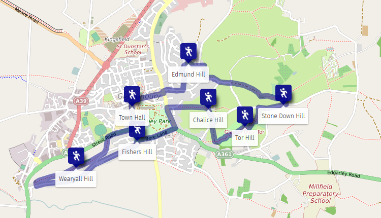
Glastonbury has 6 hills to offer:
- Edmund Hill
- Stone Down Hill
- Tor Hill
- Chalice Hill
- Fishers Hill
- Wearyall Hill
In this article I document a route I call the Glastonbury 6 Hills Trail for walkers to conquer all 6 hills in one circuit. The route is 5 miles (8 km) long and in defining the route I set some constraints:
- Must be on the public highway, public footpaths or permissive footpaths – no crossing private land
- No part of the route must be traversed more than once during the circuit
- The route must pass over the summits of each hill – in the case of Chalice Hill which is on private land, as close to the summit as possible.
Here is the trail which starts and ends at Glastonbury Town Hall though you could start and end the walk anywhere along the route:
- Town Hall -> Edmund Hill
From the Town Hall, head North towards High Street past the entrance to the Abbey before turning right into High Street.
Head up High Street crossing via the zebra crossing just past The Archers Way and before the Post Office. Continue up High Street to Wells Road and turn left into Wells Road.
Cross Wells Road at the Glastonbury Health Centre via the pelican crossing before turning right then immediately left into Bove Town.
Head up Bove Town. Just past Jacoby Cottage on the left and number 60 on the right, cross the road and head up the ramp behind the metal safety barrier where a shaded footpath with 107 steps (known locally as Jacob’s Ladder) will take you up to Windmill Hill Road.
Cross Windmill Hill Road, turn left and follow the road round to the right until it meets Chinnock Road. Turn right into Chinnock Road.
Immediately head to the left across the road and under 3 large trees to the mound behind.
- Edmund Hill -> Stone Down Hill
Head off the mound to the right of the playground towards the community hall and McColl’s to Sandpits Road (Private Road, No Parking).
Head along Sandpits Road past the last house on the right (6) and turn right alongside the house onto a muddy path.
Head along the path past a gap on the right with steps into a cul-de-sac. Do not go down the steps but continue on for a short distance until the path forks – to the left and straight on. Take the left fork into the woods and down a slope to a bench and onto the Tarmac road that is Wick Hollow.
Head up Wick Hollow past Bulwarks Lane on your right (do not turn right into Bulwarks Lane). At the junction of Maiden Croft Lane and Stone Down Lane straight ahead, pass through the pedestrian gate alongside a farm gate into the muddy lane known as Paradise Lane (do not follow the road round to the right towards the Tor or turn left into Maiden Croft Lane). Continue along the lane passing through a pedestrian gate and an open gateway before reaching a kissing gate at the end of the lane. Pass through the gate into the field. As you enter the field, on the right is a pedestrian gate leading into a narrow shaded muddy path. Pass through the gate and head along the path to a pedestrian gate at the other end of the path. Pass through the gate and turn right into Stone Down Lane.
A short distance up Stone Down Lane is the top of Stone Down Hill.
- Stone Down Hill -> Tor Hill
Continue along Stone Down Lane straight ahead through the junction with Basketfield Lane. After a short distance, turn left through the kissing gate and onto the path that takes you to the summit of Tor Hill.
- Tor Hill -> Chalice Hill
Head down the path from St Michael’s Tower in a South-westerly direction. Passing through the first kissing gate at the bottom of the path, head North along a path across the field (Fair Field) to a farm gate with a kissing gate. Pass through the gate and turn tight into Wellhouse Lane.
After a short distance turn left into Lypyatt Lane and up the lane on to the brow of the hill. The peak of Chalice Hill is on private land to the left and behind a gate onto which there are no permissive or public footpaths.
- Chalice Hill -> Fishers Hill
From the junction of Lypyatts Lane and Bulwarks Lane turn left, through the kissing gate and into Bushy Coombe.
Head down the gravel path to the kissing gate at the bottom of the Coombe and past the retreat centre to Dod Lane.
Head downhill to the junction turning left into Chilkwell Street.
Proceed along Chilkwell Street to the mini roundabout that is the junction with Bere Lane with the Somerset Rural Life Museum opposite. Cross Chilkwell Street before the junction and turn right into Bere Lane.
Proceed along Bere Lane and cross the road at number 9 towards the grassed area and continue along Bere Lane in the same direction to the junction of Bere Lane, Butleigh Road and Fishers Hill.
- Fishers Hill -> Wearyall Hill
Turn left into Butleigh Road and immediately turn right into Tor View Avenue.
Head up Tor View Avenue to the junction of Tor View Avenue, Roman Way and Hill Head. Continue straight ahead into Roman Way.
Head down, up and down! Roman Way until you are almost at the bottom of the other side of the hill. Opposite number 111 head up the steps in a gap in the wall onto a footpath signposted Wearyall Hill.
Follow the footpath round to the right and via a kissing gate onto the top of the hill between two benches.
- Wearyall Hill -> Town Hall
Follow the footpath downhill in the direction of the Tor and at the gate bear left and follow the steep footpath down towards the A361 Street Road, Tor Leisure and the town centre. Do not go through the gate at the top of the hill. At the bottom of the hill, pass through the kissing gate and turn right onto the A361 Street Road.
Continue along Street Road past Morrisons petrol station and cross the road via the zebra crossing before continuing in the same direction and turning left at the junction with Magdalene Street.
Continue along Magdalene Street crossing the road via the zebra crossing just before St Dunstan’s car park and head back to the front of the Town Hall to finish the trail.
Head over to Abbey Tea Rooms for well-deserved cream tea and add your name and date below in the Glastonbury 6 Hills Trail hall of fame!
Glastonbury 6 Hills Challenge
To fully appreciate the route it is best not rushed but if you like a brisk walk, an undulating run and a challenge here’s one for you; same route, but starting and ending inside St Michael’s Tower on Tor Hill you must complete the circuit within 60 minutes!
If you complete the challenge well done – add your name, date and time taken below in the Glastonbury 6 Hills Challenge hall of fame below.
To book holiday accommodation in the Glastonbury area visit here

